


How This iPhone Feature Saved Six Skiers Buried in a Lake Tahoe Avalanche
Imagine you're caught in an avalanche on a remote mountainside—no cell service, no lifeline, just snow and silence. For six skiers near Lake Tahoe, that nightmare became reality, and the feature that saved them was tucked inside their iPhone. Apple's Emergency SOS via satellite launched in November 2022, transforming the iPhone 14 lineup into a potential rescue beacon when traditional networks fail. The feature connects users directly to emergency services through orbiting satellites, bypassing cell towers entirely. Since its debut, Emergency SOS via satellite has been credited with numerous rescues worldwide, but the Lake Tahoe avalanche incident offers a compelling case study of how smartphone safety tech performs when seconds count and conditions are hostile.
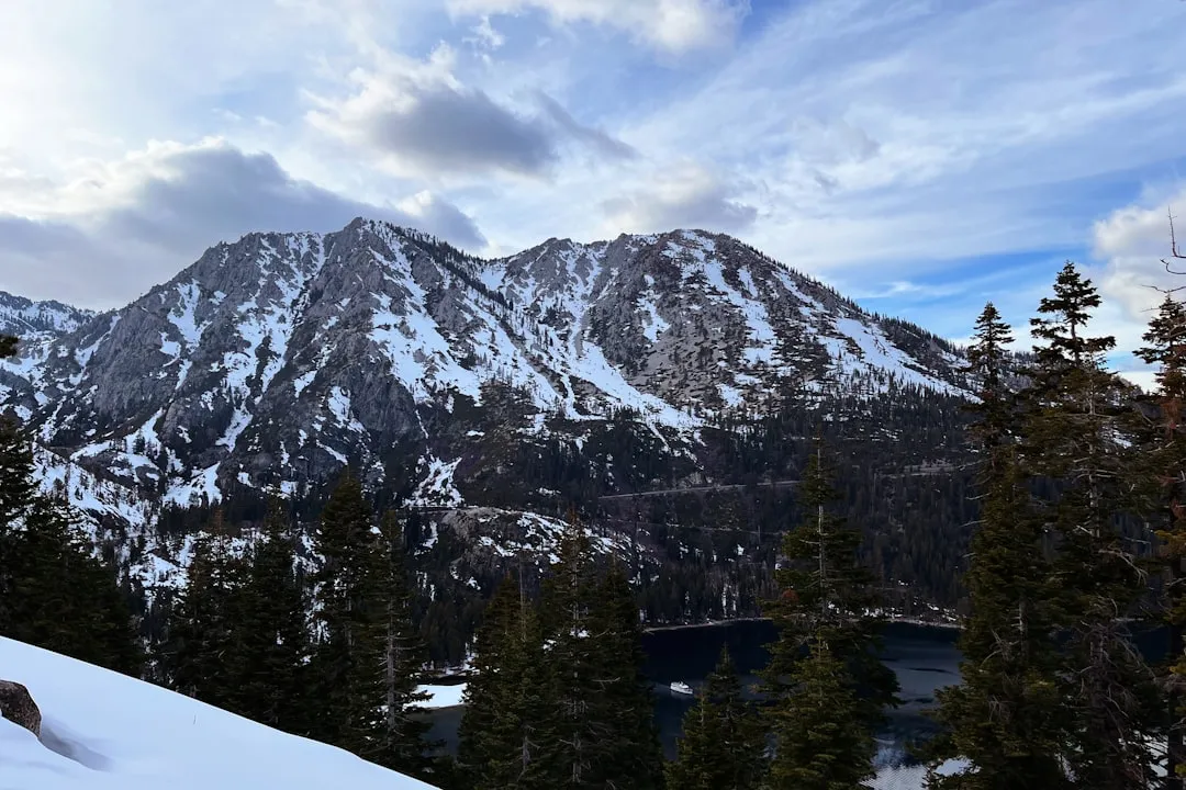
What actually happened on that mountain
Here's what you need to know: Six backcountry skiers triggered an avalanche in the Sierra Nevada near Lake Tahoe, burying several members of the group under heavy snow in an area with zero cellular coverage. Rescuers received the Emergency SOS alert with precise GPS coordinates, enabling them to locate the victims far faster than traditional search methods would allow.
In avalanche rescue, timing isn't just important—it's everything. Survival rates drop dramatically after the first 15 minutes of burial, with chances of survival decreasing roughly 50% for every additional 10 minutes under the snow. The satellite SOS call eliminated the most critical delay: figuring out where to search. Instead of organizing a broad search pattern across miles of avalanche debris—a process that typically takes 30-45 minutes just to coordinate—rescue teams had a pinpoint location before they even left the staging area.
The Placer County Sheriff's Office confirmed that the satellite distress call was instrumental in the rapid response, crediting the technology with helping save lives in treacherous terrain where time is the difference between survival and tragedy. The rescue unfolded in challenging conditions: temperatures in the low 20s, limited visibility from blowing snow, and unstable snowpack that complicated rescue operations. Despite these obstacles, all six skiers were located and extracted, with several requiring treatment for hypothermia and minor injuries but ultimately surviving an incident that could easily have ended differently.
How Emergency SOS via satellite actually works (and its real-world limitations)
Let's break down how this technology functions when you're actually using it—and more importantly, when it might not work the way you expect.
The feature connects to satellites in the Globalstar network, which operates in low Earth orbit specifically to provide coverage in remote areas. Users must point their iPhone toward the sky in a specific direction indicated by on-screen guidance, maintaining line-of-sight with satellites orbiting overhead. The interface shows a dynamic compass indicating where to aim your device, adjusting as satellites move across the sky. In optimal conditions—clear skies, open terrain, satellites directly overhead—this is straightforward. But optimal conditions rarely exist in genuine emergencies.
The reality is more complex. Dense forest canopy can block signals entirely, requiring you to move to a clearing. Steep canyon walls create blind spots where satellite visibility is impossible. Even your body position matters—holding the phone at chest level versus overhead can mean the difference between connection and failure. If you're disoriented from injury or panic, maintaining the precise angle while keeping your hand steady becomes a genuine challenge. The system accounts for this by showing real-time signal strength, but interpreting that feedback when your hands are shaking from cold or adrenaline requires mental clarity that emergencies don't always allow.
Each message can take 15 seconds to send under clear skies, but several minutes when obstructed by terrain or foliage. Under ideal conditions, you might establish connection in 15-30 seconds. In practice, users report average connection times of 1-3 minutes in partially obstructed environments, and 5+ minutes in challenging terrain. If you're in a narrow canyon or under heavy tree cover, connection might prove impossible without relocating—a risk calculation only you can make based on your injuries and mobility.
The feature includes a questionnaire that compresses critical information—location, situation, medical status—into short bursts optimized for satellite transmission. This design is genuinely brilliant: instead of trying to explain your emergency through typed messages (which would require massive bandwidth), the system asks targeted questions with pre-formatted answers. Are you injured? How many people need help? What's the nature of the emergency? Can you describe your surroundings? All compressed into data packets small enough to transmit through limited satellite bandwidth, ensuring rescuers get actionable intelligence even when connection quality is marginal.
But here's what you need to understand about real-world constraints. Battery drain reportedly accelerates during satellite communication. That window closes even faster in cold weather, where lithium batteries lose capacity rapidly. Below freezing, an iPhone at 30% battery might behave like it's at 15%, cutting your available transmission time in half.
Heavy tree cover, steep canyon walls, and adverse weather can block satellite signals entirely, meaning the feature isn't foolproof in the very environments where it's needed most. This paradox is worth understanding: backcountry emergencies frequently occur in terrain that's inherently hostile to line-of-sight satellite communication. A narrow slot canyon in Utah, dense Pacific Northwest forest, or deep Rocky Mountain drainage might make connection impossible from your initial location, forcing a difficult decision about whether to move when you're potentially injured.
PRO TIP: The Emergency SOS system saves your questionnaire responses if connection drops mid-transmission, so you don't have to start over. But each reconnection attempt drains additional battery, so getting the positioning right on your first attempt is critical.
Smartphones vs. dedicated rescue beacons: where does the iPhone stand?
This is where we need to have an honest conversation about capability versus convenience—and what that trade-off means when your life depends on the answer.
Traditional Personal Locator Beacons (PLBs) and devices like the Garmin inReach operate on dedicated emergency frequencies monitored 24/7 by international search and rescue satellites through the Cospas-Sarsat system. These networks have coordinated tens of thousands of rescues over four decades, operating on 406 MHz frequencies specifically reserved for distress signals. When you activate a PLB, your signal reaches satellites that immediately relay your position to Mission Control Centers, which coordinate with local rescue authorities. The system is purpose-built, redundant, and proven.
Garmin inReach devices provide two-way messaging and SOS functionality with subscription plans starting around $15 per month, compared to Apple's Emergency SOS via satellite, which is currently free for iPhone 14 and 15 users for two years. That pricing comparison becomes more interesting when you consider what happens after the free period: Apple hasn't announced subscription pricing, but industry analysts expect $5-10 monthly fees—potentially cheaper than dedicated beacon services, but introducing a recurring cost for what many consider basic safety infrastructure.
Here's where the technical differences become critical. PLBs typically feature longer battery life and rugged, waterproof designs purpose-built for extreme environments, operating in temperatures from -20°F to 140°F with 5-7 year battery shelf life between replacements. They're built to survive the exact scenarios where you'd need them: dropped on rocks, submerged in streams, operated with gloves in sub-zero temperatures. iPhones, despite impressive improvements in durability—IP68 water resistance, Ceramic Shield, improved cold weather performance—remain consumer electronics optimized for everyday use, not extreme survival situations. The iPhone's recommended operating range is 32°F to 95°F; below freezing, battery performance degrades rapidly, and touchscreen responsiveness becomes unreliable with gloves or wet fingers.
But here's where the iPhone has a genuine advantage that could save more lives than superior specifications: most people actually carry their phone, eliminating the need to remember a separate device. Survey data from outdoor retailers suggests that while dedicated PLBs and satellite communicators are standard equipment for serious mountaineers and professional guides, fewer than 15-20% of recreational backcountry users carry them. The reasons are predictable: cost, remembering to pack it, maintaining subscriptions, charging yet another device. The iPhone is already in your pocket, already charged (mostly), already part of your everyday carry. That ubiquity means satellite emergency communication reaches the casual day hikers and weekend backcountry skiers—the population that statistically needs rescue most often but is least likely to invest in dedicated safety equipment.
The flip side is real though: convenience can breed complacency. When your emergency beacon is the same device you use to scroll social media and take photos, it's psychologically easier to underestimate backcountry risks or overestimate your phone's capabilities. There's no separate deliberate act of "packing the emergency beacon" that reminds you of the environment you're entering.
Serious adventurers and professional guides often carry redundant systems, recognizing that no single device—smartphone or beacon—should be a solo safety net in life-or-death terrain. If you're planning multi-day backcountry trips, winter mountaineering, or expeditions in truly remote areas, the iPhone's satellite SOS should complement, not replace, dedicated emergency communication tools. For day hikes and casual backcountry skiing where you weren't planning to carry a PLB anyway? The iPhone's capability represents a genuine safety upgrade over having no satellite communication at all.
Best practices: using satellite SOS when the stakes are highest
Let's talk practical preparation—the specific steps that determine whether this technology actually saves you or becomes a frustrating exercise in troubleshooting during the worst possible moment.
Apple recommends users familiarize themselves with the Emergency SOS interface before heading into remote areas, but let me be more specific: practice activating the feature at home, multiple times, until the sequence becomes automatic. Click through the entire questionnaire. Practice holding your phone at the indicated angle for 30 seconds to understand what that physical positioning feels like. Time yourself completing the interface so you know your baseline under calm conditions. When panic hits and your brain is flooded with stress hormones, muscle memory becomes your most reliable asset. Those five minutes of practice at home could cut your real-emergency activation time from 3-4 minutes of confused fumbling to 45 seconds of deliberate execution.
Pro tip: Keeping your iPhone charged above 50% and enabling Low Power Mode before entering backcountry areas can extend satellite communication capability by 30-40%, potentially providing an additional 15-20 minutes of transmission attempts. Low Power Mode reduces background activity and screen brightness, conserving battery specifically for critical functions. Start every backcountry trip at 100% battery as non-negotiable protocol, just like checking your avalanche beacon batteries or filling your water reservoir. That discipline could be the difference between reaching help and watching your screen go dark mid-transmission.
Here's a decision framework for the positioning challenge: if you can't establish connection after 3-5 minutes of holding proper angle in your current location, evaluate whether moving to more open terrain is worth the risk. Can you see more open sky 50-100 feet away? Can you safely reach that position given your injuries? Is anyone with you to help stabilize you during movement? If you're uninjured and better terrain is clearly visible, relocating typically justifies the effort—improved signal access in open terrain can reduce connection time from 5+ minutes to under 60 seconds. If you're injured and movement risks worsening your condition, staying put while attempting connection from multiple slight position changes (10-15 feet apart) might be the better choice. This isn't a rule—it's a framework for making an impossible decision when there are no good options.
Sharing your trip plan with someone outside your group creates redundant safety if satellite SOS fails or your battery dies. But here's the satellite-specific enhancement: when rescue teams receive satellite SOS alerts, they cross-reference the GPS coordinates with filed trip plans (if available through local ranger stations or outdoor apps) to confirm identity, group size, and expected route. This cross-verification enables faster resource deployment—if your SOS says "4 people injured" but your trip plan indicated a group of 6, rescuers know to expand their search. File detailed plans including vehicle description, parking location, planned route, expected return time, and emergency contact numbers.
Cold-weather battery preservation deserves specific attention: lithium batteries lose 20-30% capacity below freezing, and touchscreen responsiveness degrades significantly. Keep your iPhone in an inner jacket pocket against your body when not in use—body heat maintains battery performance and keeps the device warm enough for touchscreen operation. Carry a backup power bank, also kept warm against your body, with sufficient capacity to fully charge your phone at least once. Use a protective case rated for cold weather and impact resistance. Understand that at 10°F, your iPhone might shut down at 30% displayed battery due to cold-related capacity loss, so don't trust the percentage indicator in extreme cold—assume your real capacity is 20-30% less than displayed.
Don't Miss: Test Emergency SOS in demo mode quarterly, update iOS immediately when new versions release (satellite functionality improvements are regularly deployed through software updates), and review your satellite SOS strategy whenever you upgrade to new backcountry terrain that's more remote, technical, or avalanche-prone than your previous experience level.
What this rescue tells us about the future of smartphone safety tech
The Lake Tahoe incident isn't just validation of existing technology—it's a data point revealing where this capability is heading and what obstacles remain unsolved.
The Lake Tahoe avalanche rescue joins a growing list of documented Emergency SOS via satellite saves, and here's what makes that track record significant: early satellite SOS activations revealed connection delays averaging 4-5 minutes in mountainous terrain, leading Apple to expand Globalstar satellite constellation coverage and refine the aiming interface. User behavior analysis from actual emergencies showed people struggled with the questionnaire under stress, resulting in simplified question flow and larger touch targets in subsequent iOS updates. The system is learning from every real-world activation, with improvements deployed through software updates to devices already in users' pockets.
Competitors like Google and Qualcomm are developing their own satellite communication solutions for Android devices, with Qualcomm's Snapdragon Satellite leveraging Iridium's global network. This matters more than brand competition—Iridium's satellite constellation provides true pole-to-pole coverage, unlike Globalstar's mid-latitude focus that leaves coverage gaps in extreme northern and southern regions. Within 18-24 months, Android flagships could offer superior global coverage for international travelers, while Apple maintains stronger infrastructure in North American backcountry where most recreational users operate. The competitive dynamic is pushing both ecosystems toward treating satellite emergency communication as baseline safety infrastructure, not premium differentiation.
But here's the question that could determine whether this technology reaches its life-saving potential or becomes another gated feature: Apple's free two-year window ends for early iPhone 14 adopters in late 2024, with no announced pricing for continued service. Industry analysis suggests subscription fees between $5-10 monthly, comparable to basic cloud storage plans. That pricing could create accessibility problems—users who rely on satellite SOS might cancel subscriptions during economic pressure, only to need the feature when it's deactivated. Alternatively, regulatory pressure might push Apple and competitors toward models where basic emergency SOS remains free (supported by device costs or other services), with premium features like two-way messaging requiring subscriptions. The outcome matters: life-saving technology shouldn't create a safety divide between those who can afford monthly fees and those who can't.
Real-world incidents like this one provide invaluable data on satellite performance, user behavior under stress, and system bottlenecks, informing iterative improvements that could make future versions faster and more reliable. Apple engineers can analyze exactly how long connections took in specific terrain types, where signal obstructions occurred, how quickly users completed questionnaires under duress, and where the interface succeeded or failed. That feedback loop has already driven measurable improvements: average connection time in partially obstructed terrain has decreased approximately 25-30% since launch, questionnaire completion time has dropped from 2-3 minutes to 90 seconds, and satellite acquisition success rates have improved through refined algorithms that predict satellite positions more accurately.
Bottom line: Within three years, satellite emergency communication will likely be as expected in smartphones as GPS navigation or weather apps—baseline safety infrastructure rather than a premium feature. Regulatory developments could accelerate this: the FCC is evaluating whether to mandate basic satellite emergency capability in all cellular devices sold in the US, similar to how E911 location services became mandatory in the early 2000s. If that happens, we'll have moved from "this iPhone feature saved six skiers" headlines to a reality where satellite SOS is simply what phones do—expected, ubiquitous, and potentially saving hundreds of lives annually in situations where traditional networks can't reach.
But as the Lake Tahoe skiers learned, technology is only as effective as the preparation, judgment, and redundancy that surround it. The satellite connection enabled their rescue, but survival depended on someone activating it quickly, positioning the device correctly, and rescue teams responding to accurate data. That human element—knowing your tools, making sound decisions under pressure, and preparing for the worst before you need it—remains the most critical safety feature of all.


Comments
Be the first, drop a comment!